 I’ve created a few Visio SmartShapes that can be easily snapped and glued into hexagonal patterns! Check it out!
Maps & Geography
Alt > File > Brexit

Fellow MVP David Parker from bVisual.net just posted a link to a very topical blog post that he made a few years ago.
Unioning Shapes, and Cleaning Them Up
 Visio has incredibly useful functions for slicing and merging shapes. But sometimes these shapes leave artifacts that can be a pain to clean up. Check out this simple trick to make it less painful!
Map of Ireland

Question: What do you think of when you hear: “Leinster, Munster, Connacht and Ulster?”
No, that’s not the name of the law firm on Boston Legal.
These are the provinces of Ireland, and today is March 17th! So Happy St. Patrick’s Day everyone!
To celebrate, we’ve got a Visio map of Ireland for you to download and put to good use.
European Cup 2008 Auto-Updating Visio Diagram (v2)

UPDATE!
Hey football/soccer fans! We’ve got an update to our automated smart drawing for this years European Cup soccer tournament.
Perhaps you are familiar with the first version, which can be found here: European Cup 2008 Auto-Updating Diagram
Well, that version needed a few updates, most notably, the handling of games that are resolved with penalty-kicks, or shoot-outs.
[Read more…] about European Cup 2008 Auto-Updating Visio Diagram (v2)
European Cup 2008 Auto-Updating Visio Diagram

Visio is a natural choice for creating brackets for sports tournaments.
I have seen many elimination-tournament diagrams created in Visio over the years. In fact, just a few years ago, a very nice example was done for the 2006 World Cup. You can get it at Office Online here: 2006 World Cup Bracket.
But the trouble with these diagrams is that they require *gasp* manual input of data, or user-movement of shapes. The horror!
Well this year, that is all going to change…
[Read more…] about European Cup 2008 Auto-Updating Visio Diagram
European Cup 2008 Country-Flag Visio Shapes
 Well Visio Fans, June is upon us, the weather is hot, and the UEFA European Cup 2008 is about to start!
Europe is going soccer crazy, and signs of Fußball-mania are everywhere! As I walk around Vienna, it’s pretty hard not to notice these ![]() waving from store-fronts and car windows.
waving from store-fronts and car windows.
Of course Visio Guy wanted to get in on the football action, so we’ve drummed up some rabble-rousing, chest-pounding Visio shapes to fan the flames of nationalistic fervor!
[Read more…] about European Cup 2008 Country-Flag Visio Shapes
Map of UK Counties and Boroughs
 David Parker, of bVisual Ltd, has created a really cool map of the UK’s counties and boroughs, and released it for download. Have a look at the article here: UK Counties and Boroughs Map Shapes for Visio.
Map of Germany
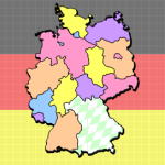 The Geographic Map Shapes & Drawings are an extremely popular feature of this web-site. And since a lot of our readers speak German, or come from Germany, it seemed like this post was long overdue.
So today we present a map of Germany and it’s states–the Bundesländer–as they are called in German.
3D Extruded Map of USA
 So we’ve had this experimental Visio drawing containing crude attempts at 3D states laying around since 1993. But we only had three states: Washington, Oregon and California. Well after a few years, a few new Visio features, and some wisdom gained, we’ve finally gotten off our butts and written a little code that helped us produce something a little more useful: an entire map of the USA, where each shape can be extruded into the vertical! [Read more…] about 3D Extruded Map of USA