 The Geographic Map Shapes & Drawings are an extremely popular feature of this web-site. And since a lot of our readers speak German, or come from Germany, it seemed like this post was long overdue.
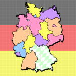
So today we present a map of Germany and it’s states–the Bundesländer–as they are called in German.
According to our statistics, readers from Germany make up the 4th largest nationality of Visio Guy readers. However, German-speaking visitors are #2 on the language-list. So Switzerland, Austria and Southern Brazil must be picking up the slack. Or perhaps there are a lot of German expats browsing from other countries.
The shapes in the drawing includes individual shapes for each of the 16 German states:
- Berlin
- Bremen
- Brandenburg
- Baden-Württemberg
- Bayern (Bavaria)
- Hamburg
- Hessen
- Mecklenburg-Vorpommern
- Niedersachsen
- Nordrhein-Westfalen
- Rheinland-Pfalz
- Sachsen-Anhalt
- Sachsen
- Schleswig-Holstein
- Saarland
- Thüringen
I didn’t translate the names into their English forms, because they pretty much the same. Perhaps Bayern is the oddest one: it is known as Bavaria in English. (Oh, Bavaria! You mean Oktoberfest!)
The drawing also includes a Custom Fill Pattern, which was used to fill in Bavaria. You can see the pattern by showing the Drawing Explorer window, available under the View menu. The pattern is called Weiss-blau, which means White-blue. the colors of Bavaria.
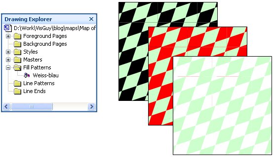
You can apply the Weiss-blau pattern via the Format > Fill dialog. Just scroll to the bottom of the Pattern drop-down list, and you’ll see the Weiss-blau entry.While the diamonds always remain blue, you can change the background color to get some very non-bavarian effects 🙂
Download “Visio Map of Germany”
This post sponsored by
USA Bahn
Products for Proud Expatriates

t-shirts – mugs – mouse-pads – notebooks
Order USA Bahn products from: Europe
Order USA Bahn products from: North America
Can you do Japan and maybe the US?
You can actually get geographic map shapes of almost all nations and states at:
http://office.microsoft.com/en-us/visio/HA010875251033.aspx
Nice work.
Thanks for sharing I love Germany I am a Germany fan