 Well, it’s been a while since any map-drawings have found their way to the Visio Guy blog-bits. And, judging by the messages I’ve been reading in the newsgroups, as well as personally receiving, there are a few more maps that you folks would like to see.
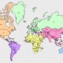
Since Mrs. Visio Guy and I are spending this year traveling around the world, it seemed appropriate that we offer up a map of the world for you to download!
So here we have it: in between hikes through rainforests, sky-diving adventures, and dolphin-watching tours, I’ve managed to produce a Visio drawing that shows all the countries of the world.
The shapes I used came from an older version of Visio (they have a copyright date of 1999), so there will have been border changes, and countries have surely appeared, been renamed, or disappeared entirely. (One change that comes to mind: Zaire is now Congo-something) But I imagine the shapes will nevertheless provide useful graphics for your geographic needs.
The drawing contains the usual Visio Guy map features, plus a few new ones:
- Each shape has a Custom Property (Shape Data field) that holds the name of the country
- Country-names are displayed on each shape on the page — this field is linked to the Custom Property (Shape Data field)
- Shapes can be automatically arranged and sized to each other via the right-click menus: Arrange to Page and Arrange to Shape
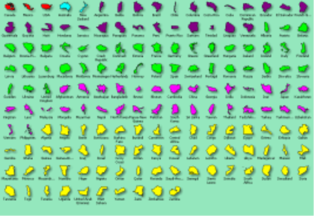
- Master shapes for each country can be found in the Document Stencil
- Master icons are color-coded by region to ease the search in a stencil with 165 masters!
(You can see there’s quite a few masters in the stencil — it’s probably just easier to copy the shapes from the drawing and paste them elsewhere!)
Happy mapping!
Download “Map of World (Visio 2002 version)”
s!Aj0wJuswNyXlhwEmXFQOYu3esics – Downloaded 31357 times – 103.00 BDownload “Map of World (Visio 5 version)”
s!Aj0wJuswNyXlhwDBbRe4nuZ-I7jw – Downloaded 13920 times – 103.00 B
I am trying to use the Visio 2002 World Map in Visio 2007. I copy all the countries to the drawing, then do an Arrange to Shape. All the countries match up, but China is missing. When I look at the list of countries, I do not see China. I re-downloaded the zip file and re-extracted the countries just to be sure.
Does anyone know what the problem is and how it might be corrected?
Thanks in advance.
Bob
Could you please show me how to add the contries name on the map?
Hi Aeolus,
You can simply select a shape, and type some text.
In the download, each shape has a Shape Data field called “Name” that stores the name of the shape. This field has been inserted (Insert > Field) as the text block for each shape. This is a bit different than typing, but opens up some data-related scenarios and programmability options.
thanks for this, tried using the microsoft one but it’s missing china and india so a bit pointless for a world map.
This one is missing singapore unfortunately but i can work around that.
Yeah, Microsoft gets in trouble legally with China and India if they ship art that has borders that each country doesn’t agree with. It’s pretty ridiculous, since most people are using these shapes as conceptual representations. Ie: “Server located in China”, and the actual borders don’t matter.
Didn’t catch the S’pore was missing, looks like I forgot to check it, lah. Of course on this map it only would be a teensy weensy quadrilateral, so you’re just as well off drawing a circle.
I would like to only shade in certain states of the US in the World Map. I downloaded the North America map but the USA doesn’t match up to the USA in the world map. Any suggestions?
Very good work. Thanks!
Great work!!!